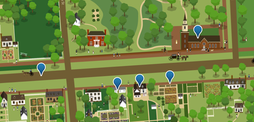
In celebration of the change of seasons, last week we rolled out a spring map for Colonial Williamsburg’s Tour the Town. The map features updated colors, blooming flowers, and other features highlighting the beautiful spring weather in Williamsburg.
You should check it out at http://tour.history.org.
Tour the Town’s technical architecture, based on OpenLayers and Drupal, offers a simple workflow for making wide-scale changes to the map. Once custom artwork is completed, it is geocoded with gdal_translate, then cut into tiles with gdal2tiles. (Both applications are available with the GDAL suite of mapping tools, and can be downloaded here.)
Related reading:
Skip to footer
Comments
